Visits: 2
– The cutting-edge research at Manam volcano in Papua New Guinea is also improving scientists’ understanding of how volcanoes contribute to the global carbon cycle, key to sustaining life on Earth and to regulating climate.
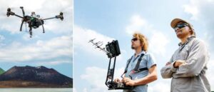
Courtesy Chalmers: Specially-adapted New drone developed by an international research team, with key participation from Chalmers scientists, have been gathering data from never-before-explored volcanoes that will enable local communities to better forecast future eruptions.
The University College London-led team’s findings, published in an article in Science Advances, show for the first time how it is possible to combine measurements from the air, earth and space to learn more about the most inaccessible, highly active volcanoes on the planet.

They co-created solutions to the challenges of measuring gas emissions from active volcanoes, through using modified long-range New drone. Pioneering work in this area was demonstrated by Chalmers scientists in 2016, when they reached the volcanic cloud of Bagana, at a height of nearly 2km, in the remote island of Bougainville.
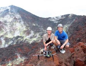
The Chalmers team, working in close cooperation with scientists of the Rabaul Volcano Observatory of Papua New Guinea, also donated an instrument for permanent monitoring of Tavurvur volcano, a volcano that erupted in 1994 and 2014, covering the town of Rabaul under ash. We were there to do science that helps to save lives, say Bo Galle, professor emeritus at Chalmers, who had been part of all field campaigns in Papua New Guinea
More data than previously possible
By combining in situ aerial measurements at Manam with results from satellites and ground-based remote sensors, researchers gathered a much richer data set than previously possible. This enabled them to monitor the active volcano remotely, improving understanding of how much carbon dioxide (CO2) is being released, and, importantly, where this carbon is coming from.
With a diameter of 10km, Manam volcano is located on an island 13km off the northeast coast of the mainland, at 1,800m above sea level.Previous studies have shown it is among the world’s biggest emitters of sulphur dioxide (SO2), but nothing was known of its CO2 output. Calculating the ratio between sulphur and carbon dioxide levels in a volcano’s emissions is critical to determining how likely an eruption is to take place.
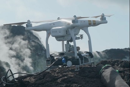
Volcanic CO2 emissions are challenging to measure due to high concentrations in the background atmosphere. Measurements need to be collected very close to active vents and, at hazardous volcanoes like Manam, the new drone are the only way to obtain samples safely. Yet beyond-line-of-sight drone flights have rarely been attempted in volcanic environments.
Adding miniaturised gas sensors, spectrometers and sampling devices that are automatically triggered to open and close, the team was able to fly the new drone 2km high and 6km away to reach Manam’s summit, where they captured gas samples to be analysed within hours.
Chalmers scientists’ experience, and the expertise of a Swedish pilot, were determinant to conduct measurements with a specially designed UAV (unmanned aerial vehicle) and ground-based sensors.

Our New drone ended up being used as a platform for measurements by other colleagues in the team, says Santiago Arellano, a Chalmers researcher who took part in the field campaign, from real-time measurement of gas composition and flux, to the collection of gas samples in bags and especially prepared gas containers, that were then used for analyses of isotopes and halogens.
This information is crucial to reveal the origin of magmas and to assess the impact of emission on the environment. The measurements could not be practically conducted in other way, concludes Arellano, who works at the division of Microwave and Optical Remote Sensing, at the Department och Space, Earth and Environment at Chalmers.
According to Santiago Arellano, working in Papua New Guinea (PNG), was challenging but highly rewarding. We had been doing fieldwork in all kinds of places in Africa, Latin America, Kamchatka. We have always had to adapt to unexpected circumstances and embrace surprises with open arms.
But in PNG we sort of had them all together. We experienced a magnitude 7 earthquake with risk of tsunami on the first night, had to stop our trip due to civil war fighting, transport all supplies and equipment by airplane, car, boat and foot across the rivers…a long list. But we also got to know and learn from extraordinary people, generous and resilient, who had their own relationship with the volcanoes. You realize volcanoes are not only targets of scientific research, but they are primarily part of the environment where thousands of people live and dream.
Volcanoes emit gases before and during eruptions, mostly water vapor and gases containing carbon and sulfur. CO2 is released from very deep, before the other gases, and therefore it can give an early signal of unrest of a volcano. If the emission is at low altitude it can be a threat to life, if it gets too high, it can even alter the climate.
At a global level, all volcanoes of the world emit together about a thousand of what human activities do, unless there would be a Toba-like eruption (the largest volcanic eruption on Earth, in Sumatra 70 000 years ago). A key difference though, is that we cannot control the emission from volcanoes.
If the source of emission is magma (molten deep lava) from the mantle, the implication is totally different than if it comes, say from biogenic activity or sediments in the crust, because it would mean that the volcano is active and may produce an eruption. Usually the origin is revealed by the isotopic composition, for which samples need to be taken from concentrated sources of gas, dangerous to people but not to drones.
Chalmers had demonstrated the application of New drone to reach high-altitude volcanic clouds during field campaigns in Papua New Guinea in 2016 (Tavurvur, Bagana, Ulawun, and 2018 (Langila). Common challenges to these were technical (reaching up to 2500 m height above ground and 5 km distance, piloting without seeing the drone), and logistical (very remote volcanoes, basic infrastructure, import restrictions, etc.).
We initiated a good cooperation with the local Rabaul Volcano Observatory and contributed also with measurements from ground, which was the initial expected contribution of our group to an international team that included colleagues from Cambridge, Bristol, Palermo, Heidelberg/Mainz, New Mexico, Costa Rica, and of course PNG.
The ABOVE campaign was the final effort of the 10-year Deep Carbon Observatory project and had the ambition to join groups developing the new drone applications on volcanoes for a dedicated campaign in Manam, one of the strongest gas emitters in the world, and also one of the less well known. Our approach was successful to obtain the data that we were committed to provide and to help other groups to achieve their measurements.
We pinpointed the source and magnitude of emissions of carbon and sulfur on these volcanoes, key to improve estimates of worldwide volcanic gas emission. The project gave a push forward to creating new instrumentation and methodologies to combine measurements from ground and air to make observations that otherwise would not be possible. We had maintained the cooperation with the other groups, but of course no more fieldwork has been possible in this year. These new drone developments will hopefully be used for research on emissions from ship and industries by our group at Chalmers, says Santiago Arellano.
The ABOVE – Aerial-based Observations of Volcanic Emissions – project
The ABOVE project was led by University College London and involved specialists from the UK, USA, Canada, Italy, Sweden, Ecuador, Germany, Costa Rica, New Zealand, and Papua New Guinea, spanning remote sensing, volcanology and aerospace engineering. Vladimir Conde, Johan Mellqvist, Jiazhi Xu, Gustav Gerdes and Tomas Krejci were also involved in Chalmers instruments and drone developments. ABOVE was funded by the Alfred P. Sloan Foundation. Chalmers UAV research has been supported by FORMAS and the Swedish National Space Board.
Other sources: ABOVE
Related article: Novel and improved mapping software for drone